The Mississippi River is the primary river, and second-longest river, of the largest drainage basin in the United States. From its traditional source of Lake Itasca in northern Minnesota, it flows generally south for 2,340 miles (3,766 km) to the Mississippi River Delta in the Gulf of Mexico. With its many tributaries, the Mississippi's watershed drains all or parts of 32 U.S. states and two Canadian provinces between the Rocky and Appalachian mountains. The main stem is entirely within the United States; the total drainage basin is 1,151,000 sq mi (2,980,000 km2), of which only about one percent is in Canada. The Mississippi ranks as the thirteenth-largest river by discharge in the world. The river either borders or passes through the states of Minnesota, Wisconsin, Iowa, Illinois, Missouri, Kentucky, Tennessee, Arkansas, Mississippi, and Louisiana.

St. Martin Parish is a parish located in the U.S. state of Louisiana, founded in 1811. Its parish seat is St. Martinville, and the largest city is Breaux Bridge. At the 2020 census, the population was 51,767. St. Martin Parish is part of the Lafayette metropolitan area in the region of Acadiana, along the Gulf Coast.

Krotz Springs is a town in St. Landry Parish, Louisiana, United States, on the Atchafalaya River. The population was 1,198 at the 2010 census, down from 1,219 in 2000. It is part of the Opelousas–Eunice Micropolitan Statistical Area.

Melville is a town in St. Landry Parish, Louisiana, United States. The population was 1,041 at the 2010 census. It is part of the Opelousas−Eunice Micropolitan Statistical Area. It was founded in 1889 and is known as the Atchafalaya River Catfish Capital of Louisiana.

The Gulf Intracoastal Waterway (GIWW) is the portion of the Intracoastal Waterway located along the Gulf Coast of the United States. It is a navigable inland waterway running approximately 1,300 mi (2,100 km) from Saint Marks, Florida, to Brownsville, Texas.

Bayou Teche is a 125-mile-long (201 km) waterway in south central Louisiana in the United States. Bayou Teche was the Mississippi River's main course when it developed a delta about 2,800 to 4,500 years ago. Through a natural process known as deltaic switching, the river's deposits of silt and sediment cause the Mississippi to change its course every thousand years or so.

The Atchafalaya River is a 137-mile-long (220 km) distributary of the Mississippi River and Red River in south central Louisiana in the United States. It flows south, just west of the Mississippi River, and is the fifth largest river in North America, by discharge. The name Atchafalaya comes from Choctaw for 'long river', from hachcha, 'river', and falaya, 'long'.

The Old River Control Structure is a floodgate system in a branch of the Mississippi River in central Louisiana. It regulates the flow of water from the Mississippi into the Atchafalaya River, thereby preventing the Mississippi River from changing course. Completed in 1963, the complex was built by the U.S. Army Corps of Engineers in a side channel of the Mississippi known as "Old River", between the Mississippi's current channel and the Atchafalaya Basin, a former channel of the Mississippi.

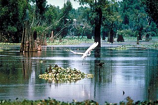
The Atchafalaya Basin, or Atchafalaya Swamp, is the largest wetland and swamp in the United States. Located in south central Louisiana, it is a combination of wetlands and river delta area where the Atchafalaya River and the Gulf of Mexico converge. The river stretches from near Simmesport in the north through parts of eight parishes to the Morgan City southern area.
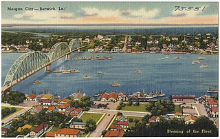
Berwick Bay is the section of the Lower Atchafalaya River in Louisiana from Morgan City north to Sixmile Lake. U.S. Route 90 crosses Berwick Bay connecting the town of Berwick on the west bank of the Atchafalaya to Morgan City on the east bank. There is also a Southern Pacific vertical lift bridge connecting the two municipalities. This stretch of water lends its name to Vessel Traffic Service Berwick Bay which manages the waters south of 29°45' N., west of 91°10' W., north of 29°37' N., and east of 91°18' W. These waters include the junction of the Gulf Intracoastal Waterway, the Port Allen-Morgan City Alternate Route and several tributary bayous. Narrow bridge openings and a swift river current require one-way traffic flow through the bridges. VTS Berwick Bay is unique among United States Coast Guard Vessel Traffic Services because it maintains direct control of vessel traffic.

The Battle of Yellow Bayou, also known as the Battle of Norwood's Plantation, saw Union Army forces led by Brigadier General Joseph A. Mower clash with Confederate States Army troops commanded by Brigadier General John A. Wharton in Avoyelles Parish, Louisiana during the American Civil War. This was the final action of the Red River campaign in which a Union army under Major General Nathaniel P. Banks was repulsed by Confederate forces led by Major General Richard Taylor. The failed Union campaign almost ended in disaster when an accompanying Union fleet led by Rear Admiral David Dixon Porter was trapped at Alexandria, Louisiana, by low water in the Red River. An engineering feat saved the fleet, allowing Banks' army to complete its withdrawal.
East Krotz Springs is a ghost town that was located in Pointe Coupee Parish's 1st Ward, approximately 12 miles west of Livonia, Louisiana, United States. The site of the town itself is located at coordinates 30°32'12.87"N, 91°44'24.59"W, and is abandoned. United States Geological Survey maps from 1948 show the town to be located on the east bank of the Atchafalaya River at the mouth of Bayou Sherman, directly across from Krotz Springs, south of the railroad bridge.
Torras is the name of a former town in the extreme northeastern corner of Pointe Coupee Parish, Louisiana, United States. The town was located along either side of the Texas & Pacific Railroad at its juncture with Lower Old River. The Mississippi River is located just to the east and the juncture of the Red and Atchafalaya Rivers just to the west.
The Battle of Stirling's Plantation was an American Civil War battle took place on September 29, 1863 in Pointe Coupee Parish, Louisiana.

The Atchafalaya Basin Bridge, also known as the Louisiana Airborne Memorial Bridge, is a pair of parallel bridges in the U.S. state of Louisiana between Baton Rouge and Lafayette which carries Interstate 10 over the Atchafalaya Basin. With a total length of 96,095 feet, it is the third longest bridge in the US, the second longest on the interstate system, and 14th-longest in the world by total length.
Bayou Chene was previously a small unincorporated community in St. Martin Parish, Louisiana, United States. The community was located in the Atchafalaya Basin.

Wax Lake was a lake in St. Mary Parish, Louisiana that was converted into an outlet channel, the Wax Lake outlet, to divert water from the Atchafalaya River to the Gulf of Mexico.

The Long–Allen Bridge is a truss bridge in the U.S. state of Louisiana which carries LA 182 over the Atchafalaya River between Berwick and Morgan City.

The West Atchafalaya Floodway is a flood control structure of the Mississippi River and Tributaries Project located in the Lower Atchafalaya Basin in south-central Louisiana. It has a project design flood flow capacity of 250,000 cu ft/s (7,100 m3/s).
Atchafalaya is a ghost town that was located in St. Martin Parish, approximately 6 miles north of Butte La Rose, Louisiana, United States and just north of I-10 on the Atchafalaya River. The site of the town itself is located at coordinates 30°20'40.9"N 91°43'26.8"W, and is abandoned. United States Geological Survey maps from 1935 show the town to be located on the east bank of the Atchafalaya River at the Southern Pacific Railroad crossing, which was built in 1908. After the bridge was damaged due to the Great Mississippi Flood of 1927, the railroad from Lafayette to Baton Rouge was abandoned a few years later. With no transportation in and out, the town population began to dwindle, with the last resident leaving in 1959. There is no visible trace of the town left today.


